
Retreat. Adapt. Defend Blueprints: Designing Community Response to Sea Level Rise in Five Coastal Georgia Communities
Water - quality, quantity and accessibility - is a central issue in the State of Georgia and across the world. The Georgia Conservancy works to address water challenges through statewide advocacy, education and research, advancing awareness through stewardship trips and land conservation.. Sea level rise is an emerging issue of concern to coastal communities in Georgia and will have future consequences for the entire state.
This Design + Research Blueprints project concentrates on sea level rise challenges and adaptation opportunities for five communities along the Georgia coast: City of Savannah, Tybee Island, City of Darien, City of Brunswick, and City of St. Marys. These locations were selected because of their various geographic positions along the coast, as well as their different challenges and opportunities.
Georgia’s coastal population, economic activity and cultural opportunities will continue to be drawn to, and benefit from, a relationship with the water-- but what shape will the built environment of communities take on in the future? Cities across the globe are beginning to understand the implications of climate change and coastal communities are exploring options to defend, retreat or adapt to changing conditions.
A Blueprints team, composed of Georgia Conservancy staff, Professor Richard Dagenhart, Dr. Tom Debo and graduate students in a Georgia Tech College of Architecture Design + Research Studio spent almost six months preparing this report. The team made site visits, interviewed government officials, residents and business owners, collected data and reviewed other communities’ planning and design strategies for sea level rise. The studio was multidisciplinary, including students in the Master of Science in Urban Design, Master of Architecture and Master of City and Regional Planning. The Studio developed alternative planning and design approaches for the five coastal communities and developed a set of draft recommendations for stakeholder consideration. These recommendations are supported by Blueprints advisers and form the basis of this report.
The final output of the process is this Blueprints report, which aims to educate communities across the state and to begin considering responses to climate change and sea level rise. Although these recommendations are not aimed at immediate implementation, we hope the design and planning proposal will draw attention the issues of sea level rise, stimulate conversations, and help begin the process of making appropriate decisions today that will guide future decision over the coming decades.
Executive Summary
Based on measurements indicating a significant rise in Earth’s sea levels since 1935, scientists have projected that by the year 2110, the surface of the oceans on the Georgia coast will be approximately one meter above today’s levels. While this prognosis is significant and potentially devastating, the change will be incremental. We are fortunate to have the opportunity to take advantage of the early warnings and to investigate the effects that a sea level rise of this extent would have on our population, our natural and built environments, and our economy.
In 2012, the Georgia Conservancy sponsored a studio of graduate students studying city and regional planning at Georgia Tech to investigate the impacts of sea level rise in three coastal counties (Chatham, Liberty and McIntosh) and to detail policy- and planning-related adaptation opportunities (Georgia Conservancy 2012). The studio found that one meter of sea level rise would inundate nearly one third of the three-county study area, with a disproportionate impact on parks and conservation land, particularly wetlands areas. The team also found significant inundation of residential and waterfront commercial properties, inundation of 13 miles of state and national highways, and the flooding of railroads.
This RETREAT. ADAPT. DEFEND Design + Research report is based on, but also expands on, the past studio’s work on the Georgia coast, particularly addressing sea level rise’s impact on the five selected sites and what this means to the future of the built environment and how to incrementally plan for changes. The studio was divided into teams of at least three students to address the sites and develop adaptation scenarios. A brief description of each site’s challenges and opportunities is presented below.
The City of Savannah site is focused within the city limits, just east of the Historic District in the “East Savannah Gateway” neighborhood. Much of the property is owned by the Savannah Housing Authority, who has been tasked with redeveloping demolished housing projects. The site is located very near the Savannah River and within a historic rice plantation, which makes the site especially susceptible to flooding. Previous mitigation ideas have included raising President Street, which forms the northern boundary of the site and is a major east/west corridor in the city.
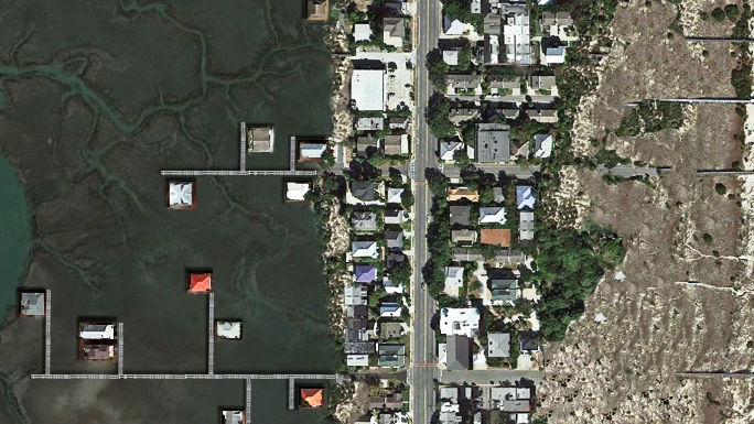
Tybee Island is the eastern-most point on the Georgia coast, and a popular spot for beach tourists. Previous studies show that one meter of sea level rise will not only cover about half of the island, but also US-80, the only vehicular access on and off of the island. US-80 already faces severe flooding issues during storms, leaving citizens stranded until the water recedes. The island also faces flooding issues, particularly on the west side where marshes have been damaged by a long process of converting wetlands into residential areas.
RE-visioning Tybee Island
The City of Darien is a small town of about 2,000 residents, and is the second oldest planned community in the state of Georgia. The oldest English colonial fort on Georgia’s coast, Fort King George, was built in 1721 and its reconstruction draws tourists to Darien. The town sits on a bluff on the Altamaha River with an economy based on fishing and shrimping. Recreational tourism and attractive retirement and second-home settings are creating a growing opportunity for Darien.

Darien Waterfront, west harbor
The City of Brunswick is the second-largest urban area on the coast and is the major urban and economic center in this southeastern part of Georgia. The Port at Brunswick served historically as a strategic military location in WWII, and currently handles 10% of all U.S. ro-ro (roll-on/roll-off wheeled cargo) trade.
The City of St. Marys dates back to the mid-16th century as part of the Spanish settlement in St. Augustine, Florida. The center of the town has been designated as a Historic District by the National Register of Historic Places. Notable features include the waterfront area, historic cemetery, and a memorial oak tree. St. Marys is also home to the Naval Submarine Base Kings Bay, which covers about 16,000 acres of land, of which 4,000 acres are protected wetlands. Additionally, St. Marys is the gateway to the Cumberland Island National Seashore, Georgia’s largest and one of the most undeveloped barrier islands on the Atlantic coast.

St. Marys Waterfront
Conclusions
Several decades of empirical evidence demonstrate that sea levels are rising. The scientific community projects ranges of possible sea level increases over a certain number of years – two to three feet in 80 years. But time is elastic – sea levels will rise, but we do not know how much in what period of time. Urban design, planning and civil engineering must anticipate and design for sea level rise foot by foot, not feet in time.
Ecological conditions of coastal areas, not protection of property values, should guide all decisions on the Georgia Coast. Different decisions may be made in other coastal situations – South Florida or Manhattan, for example. The Georgia Coast is ideally suited for ecology to come first because of its ability to mitigate and adapt to sea level rise. In all coastal areas, urban design, planning and civil engineering design strategies should be based upon long term retreat, to allow the ecology to mitigate rising seas, tidal events, and storm surge.
Given that time is elastic and ecological protection is paramount on the Georgia Coast, design strategies should be incremental. One foot. Two feet. Three feet. And so on. This can anticipate both gradual and catastrophic rise. As property values and real estate taxes decline in coastal areas, investments need an incremental approach to defend, to adapt, and to retreat. Major defensive infrastructure investments are unwise. Similarly, major investments to retreat are unwise. Incremental adaption along the Georgia Coast should be the first aim.
Learn more about the Georgia Conservancy's Sea Level Rise Blueprints Studios
The Conservancy's sea level rise work would not be possible without the generous support of The Home Depot Foundation, Gulfstream and the Ray C. Anderson Foundation, as well as the indispensable data supplied by Dr. Clark Alexander at the Skidaway Institute of Oceanography in Savannah.
If you have any questions regarding our Retreat. Adapt. Defend Blueprints Studio or would like to purchase a print version of the Final Report, please contact Georgia Conservancy Senior Planner Nick Johnson at njohnson@gaconservancy.org.